Paper
Chin, W. C. B. (2023) Delineating Zones of Disease Diffusion from the Amenity-Sharing Network in Peninsular Malaysia. In Wen, TH., Chuang, TW., Tipayamongkholgul, M. (eds.) Earth Data Analytics for Planetary Health. Atmosphere, Earth, Ocean & Space. (pp. 143-167). Springer, Singapore. ISBN:978-981-19-8765-6. DOI:10.1007/978-981-19-8765-6_8
Abstract
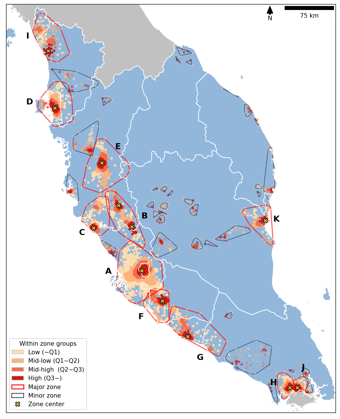
Disease diffusion happens when infected and susceptible individuals move around and closely interact with each other. The boundary of human movement can be found by analysing the locations of amenities and people. The human movement boundaries can be considered as the zones of disease diffusion, which is essential for the establishment of disease control measures. During the COVID-19 pandemic, Malaysia had gone through a series of nationwide Movement Control Orders (MCO)—multiple phases of country/city lockdown measures—starting from March 2020. One key order during MCO was to restrict the travel distance to a 10 km radius from household locations. However, this movement restriction can only eliminate/reduce the long-range disease spreading (relocation) but not the disease diffusion within a local area (expansion). The disease can still be transmitted within a neighbourhood and between closely located or densely interacted neighbourhoods. In other words, people who visited the same region of an outbreak cluster would still expose to the disease. This study analyses the boundaries of densely connected neighbourhoods based on the amenity-sharing relationships, i.e., the disease diffusion zones, and identify the vulnerable locations in terms of spreading and contracting diseases, i.e., the centre(s) of zones. Using Peninsular Malaysia as a case study, a four-step framework was established, which utilised the open-data materials and open-source software. The analysis results from the case study showed that while some of the zones resembled the administrative boundaries, a considerable proportion of the zones extended the city area to the neighbouring urbanised area while some zones split a city into separated zones. These identified zones function as a reference for future policymaking on disease control issues.
Read article here:
- Official website: Delineating Zones of Disease Diffusion from the Amenity-Sharing Network in Peninsular Malaysia, Earth Data Analytics for Planetary Health,
- ResearchGate: Abstract and full text (on request or downloadable directly),
- Please contact me (by Gmail ).