After this page, you should be able to:
Distinguish exact, range and nearest questions, including their boundary and distance contracts.
Explain why a region bound can justify pruning while a single outside point cannot.
Builds on: BST range reporting already uses ordering to exclude subtrees.
Code languages: Python defines the explanations, figures and self-checks. Use the language guide for native conventions and dependencies. Complete runnable topic examples: Python · JavaScript · Julia.
JavaScript points are arrays compared by same_point; Julia points are value tuples. Julia coordinate/child indices are one-based (x=1, y=2; SW/SE/NW/NE=1/2/3/4), while depth still starts at zero. R-tree orientation uses exact big-integer arithmetic for the supplied integer-coordinate geometry; nearest distances remain floating calculations. General R-tree update code is still conceptual in every language.
Specify the objects and the question
Spatial search uses coordinates and extents to exclude impossible answers. Exact lookup asks whether a point is stored; range reporting asks which objects meet a region; nearest-neighbour search asks which object minimises a specified distance. A structure useful for one workload need not be best for every workload.
For point range reporting, this topic uses a closed query rectangle (xmin, ymin, xmax, ymax): touching an edge or corner counts. Stored point duplicates represent one point, not several records. Applications needing several observations at the same coordinate should attach a collection of record identifiers rather than silently discard observations.
Keep the data and query fixed while changing the index
from math import isfinite

shared_points = [(5, 4), (2, 7), (8, 1), (1, 3),
                 (3, 6), (7, 5), (9, 2)]
shared_query = (1, 2, 4, 7)

def checked_rect(rect):
    if len(rect) != 4 or not all(isfinite(v) for v in rect):
        raise ValueError("rectangle needs four finite numeric coordinates")
    xmin, ymin, xmax, ymax = rect
    if xmin > xmax or ymin > ymax:
        raise ValueError("rectangle bounds are reversed")
    return tuple(rect)

def in_closed_rect(point, rect):
    x, y = point
    xmin, ymin, xmax, ymax = rect
    return xmin <= x <= xmax and ymin <= y <= ymax

def scan_range(points, rect):
    rect = checked_rect(rect)
    return [p for p in points if in_closed_rect(p, rect)]
var shared_points = [[5,4],[2,7],[8,1],[1,3],[3,6],[7,5],[9,2]], shared_query = [1,2,4,7];
function same_point(a,b) { return a[0] === b[0] && a[1] === b[1]; }
function checked_rect(rect) {
if (rect.length !== 4 || !rect.every(Number.isFinite)) throw new RangeError("four finite coordinates required");
if (rect[0]>rect[2] || rect[1]>rect[3]) throw new RangeError("reversed bounds");
return [...rect];
}
function in_closed_rect([x,y],[xmin,ymin,xmax,ymax]) { return xmin<=x && x<=xmax && ymin<=y && y<=ymax; }
function scan_range(points,rect) { rect=checked_rect(rect); return points.filter(p=>in_closed_rect(p,rect)); }shared_points = [(5,4),(2,7),(8,1),(1,3),(3,6),(7,5),(9,2)]
shared_query = (1,2,4,7)
function checked_rect(rect)
(length(rect)==4 && all(isfinite,rect)) || throw(ArgumentError("four finite coordinates required"))
(rect[1]<=rect[3] && rect[2]<=rect[4]) || throw(ArgumentError("reversed bounds"))
return Tuple(rect)
end
function in_closed_rect(point,rect)
x,y=point; xmin,ymin,xmax,ymax=rect
return xmin<=x<=xmax && ymin<=y<=ymax
end
function scan_range(points,rect)
rect=checked_rect(rect); return [p for p in points if in_closed_rect(p,rect)]
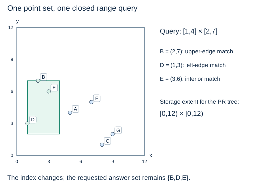
endThe points are A through G in the order shown. The shared query returns B=(2,7), D=(1,3), E=(3,6). These are the same coordinates and inclusive bounds as the existing k-d-tree pages. The helpers assume numeric coordinate pairs; they validate rectangle order and finiteness, not arbitrary object types. The shared list contains distinct points. For another dataset, deduplicate before comparing with these point-set indexes; the scan itself reports the supplied records. Comparing result sets avoids confusing a traversal-order difference with a wrong answer.
A scan is both a baseline and a check
Scanning n point records takes time and result storage for r answers under fixed-cost coordinate comparisons. An index adds construction, persistent storage and update work. On a tiny collection or a query returning almost everything, a scan may be a sensible choice.
A uniform grid is another baseline: fixed cells store point buckets, and a range query inspects intersecting cells. It avoids a tree but introduces a cell-size choice. Adaptive trees organise subdivision or grouping differently; none eliminates the cost of returning many records.
Reject a region only when it cannot contribute
A point outside a rectangle does not prove its descendants are outside. Pruning needs a bound on all possible descendants: an inherited partition cell or an enclosing object rectangle. If that bound cannot meet the query, its subtree can be skipped.
For nearest search, a rectangle supplies a lower bound. With query (qx,qy), let and similarly for y. Then is the squared Euclidean distance to the closed rectangle. If it exceeds the best distance found, nothing enclosed can improve the answer. A half-open cell’s closure still supplies a safe lower bound. The current full nearest-neighbour implementation remains in the k-d-tree reading.
Coordinates need an interpretation
The shared coordinates are invented planar units, not longitude and latitude. Euclidean distance in longitude/latitude degrees is not automatically ground distance in metres. Select a distance model and compatible coordinates before interpreting nearest results. The schematic placement of a point and the chosen index cannot supply missing geographic meaning.
Check your understanding
Predict the answer before opening the explanation.
1. Which shared points belong to the closed rectangle [1,4] × [2,7]? Explain the two boundary cases.
Show explanation
B=(2,7), D=(1,3) and E=(3,6). B is on the included upper y edge; D is on the included lower x edge. E is in the interior. A=(5,4) lies outside even though descendants of A in a point tree can be answers.
2. Could (12,6) satisfy the closed query rectangle (11,5,12,7) yet be rejected by a PR tree whose storage extent is [0,12) × [0,12)?
Show explanation
Yes. The query includes its maximum x edge, so its predicate accepts (12,6). The storage extent excludes x=12, so that PR tree rejects insertion. A query boundary defines what to report; a storage boundary defines which tree cell owns a record.
Next: The k-d-tree method, then follow construction, exact, range, shape, nearest and deletion in sidebar order. Point quadtrees follow that group.